Back بينسفيل (ماريلند) Arabic بننزویل، مریلند AZB Bennsville Catalan Bennsville (lungsod sa Tinipong Bansa, lat 38,62, long -77,01) CEB Bennsville (Maryland) Spanish Bennsville (Maryland) Basque بنسویل، مریلند Persian Bennsville Italian Бэннсвил (Мэриленд) Kazakh Бэннсвил (Мэриленд) Kirghiz
Bennsville (Bensville), Maryland | |
|---|---|
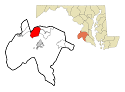
 Location of Bennsville, Maryland | |
| Coordinates: 38°37′24″N 77°0′23″W / 38.62333°N 77.00639°W | |
| Country | United States |
| State | Maryland |
| County | Charles |
| Area | |
| • Total | 16.91 sq mi (43.78 km2) |
| • Land | 16.90 sq mi (43.78 km2) |
| • Water | 0.00 sq mi (0.00 km2) |
| Elevation | 184 ft (56 m) |
| Population (2020) | |
| • Total | 15,288 |
| • Density | 904.40/sq mi (349.19/km2) |
| Time zone | UTC−5 (Eastern (EST)) |
| • Summer (DST) | UTC−4 (EDT) |
| FIPS code | 24-06615 |
| GNIS feature ID | 0589738 |
Bennsville[2] (spelled Bensville by the United States Census Bureau[3]) is a census-designated place (CDP) in Charles County, Maryland, United States. Per the 2020 census, the population was 15,288.[4] The area is not an official postal designation, but is part of the Waldorf or Pomfret postal area. The Bennsville area is growing with new residential development, encouraged by the extension in the 1990s of Maryland Route 228 which provides quick access to Maryland Route 210. Bennsville has experienced the 2006 opening of North Point High School and the straightening of Middletown Road in 2008.
- ^ "2020 U.S. Gazetteer Files". United States Census Bureau. Retrieved April 26, 2022.
- ^ U.S. Geological Survey Geographic Names Information System: Bennsville, Maryland
- ^ "Geographic Identifiers: 2010 Demographic Profile Data (DP-1): Bensville CDP, Maryland". United States Census Bureau. Retrieved August 3, 2012.
- ^ "Bensville CDP, Maryland". United States Census Bureau. Retrieved April 15, 2022.